Reference soil Thailand 01 Fluvisol
TH001
Distribution of Fluvisols (rough estimation supplied by soilgrids)
MICRORELIEF: shallow furrows and low ridges occur locally, caused most probably by ploughing. CRACKING: cracks about 1 cm wide and 20 cm deep (may be as deep as 40 cm).
FLOODING: by rain and river water, for 7 to 8 months of the year.
VEGETATION AND LAND USE: Palynological data of subsoil samples from two sides in the tidal marshes, viz. east of Pathum Thani and southeast of Ayutthaya, indicate that at the time of deposition the vegetation in these marshes consisted dominantly of mangrove species (69-93%), mainly Rhizophoraceae (Pons and Van der Kevie, 1969), with a subordinate amount of various ferns and grasses. As the influence of the tides lessened, the mangrove forest gave initially way to a fresh water forest (Van der Kevie, 1971). This gradually changed to a vegetation of mainly tall grasses, rushes and sedges, which form the present day natural vegetation of the Bangkok Plain (Van Bremen, 1976). Clearing of the natural vegetation commenced about a century ago because of a growing demand for rice. At present management practices include ploughing (water buffalo or tractor), :incidental application of fertilizers, and burning of the straw. Most of the area is now under cultivation (floating rice). Average rice yield is 1000 kg/ha.
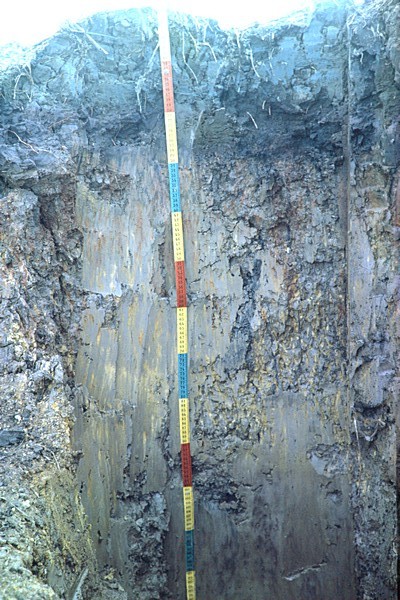
ADDITIONAL NOTES ON PROFILEDESCRIPTION :
Bg1: also many coarse prominant red (10R 4/6) mottles; inclusion: black; cutans: also black along some fine pores;
Bg2: inclusions: black (10YR 2/1) probably filled-up cracks; cutans: black, along some fine pores;
Bg3: sulfuric horizon; mottles: also coarse; cutans: black, along; some fine pores;
Bg4: soap clay horizon; colour slightly darker in some spots as mentioned above.
REFERENCES: Spaargaren, O.C., Creutzberg, D., et al, 1981. ISM Soil Monolith Paper no. 1. Thionic Fluvisol (Sulfic Tropaquept), Central Plain Region, Thailand.
Classification
| WRB 2014 | |||
|---|---|---|---|
| Fluvisol | |||
| cm | sulfuric horizon | ||
| cm | umbric A horizon | ||
| - | sulfidic materials | ||
| FAO-UNESCO-ISRIC 1974 | |||
| Thionic Fluvisol | |||
| cm | sulfuric horizon | ||
| cm | umbric A horizon | ||
| -- | sulfidic material | ||
Local classification : Hydromorphic alluvial soil
Other classification
USDA-NRCS (1999) Typic Sulfaquept
USDA-SCS (1975) Typic Tropaquept aquic clayey mixed isohyperthermic
Location:
Ayutthaya Province, Wang Noi District, 5km NW of Wang Noi. 20 m E of Phaholyothin highway, 800 m N of kmp. 70, (topographical sheet nrs. 5153 I and IV of the AMS Topo Map Series L.708).