Reference soil China 21: Acrisol
Acrisols occur dominantly in the wetter parts of the tropics and subtropics and the warm temperate regions in relatively young landscapes.
Characteristics
Soils having an argic horizon (a subsurface horizon with distinct higher clay content than the overlying horizon), which has a cation exchange capacity of less than 24 cmolc per kg in some part, either starting within 100 cm from the soil surface, or within 200 cm from the soil surface if the argic horizon is overlain by loamy sand or coarser textures throughout. They have a base saturation (total amount of Ca, Mg, K and Na with respect to the cation exchange capacity) of less than 50 percent in the major part between 25 and 100 cm from the soil surface
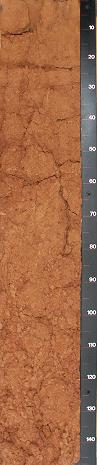
Reference soil CN021: Acrisols
General remarks PROFILE DESCRIPTION : Very deep, well drained, reddish brown to red clay derived from Quaternary clay. The topsoil is nearly structureless. The upper subsoil has a subangular blocky structure while the deeper subsoil has an angular blocky structure and is strongly mottled. The soil is compact, there are mainly micro pores and few very fine to fine pores. Soil permeability is judged to be reduced, especially in the strongly mottled deeper subsoil, where ped surfaces are covered by clay cutans and which shows very few pores. The soil surface is smooth and has a thin seal. Especially on eroded bare soil surfaces a bio-seal may be formed, reducing even more the infiltration capacity of the topsoil for rain. GENERAL LANDFORM: the intermontane basins in Southern China are known as 'Red Basins'. At Yingtan the width of the basin is about 30 km. The basin has a plain appearance and consists of nearly level to undulating interfluves (low broad hills) with broad, nearly level valleys / LAND USE AND VEGETATION: the Red Quaternary Clay soils of the interfluves are not used for cultivation by the farmer. Present vegetation is sparse grass cover and Masson Pine planted about 15 years ago. Growth is slow (height about 4 meters and diameter 8 cm) / SLOPE PROCESSES: the Red Quaternary Clay soil interfluves (hills) are affected by erosion. This is caused by the high run-off, resulting in sheet erosion. On middle and lower slopes, run-off water concentrates and severe gully erosion may occur. Erosion is man-induced, because the original broad-leaved forest has been cleared long ago. Before the use of inorganic fertilizers, the grass/herb vegetation with some topsoil was removed for the fertilization of the paddy fields in the valley. At present this practice is not used anymore, however, the litter is still frequently collected by farmers for kitchen fuel. This still reduces the vegetation cover, incorporation of organic matter in the topsoil and bio-activity and therefore still enhances the run-off and erosion.